

Abstract: The temple is located in the district Cetho Karanganyar, Java Tenggah. This
temple is a prehistoric relic temple, Hindus, and even today the temple
is still in use as a place for the Hindu Religious ritual, whether that
is around temples or people from outside the area who just want to
enjoy and feel the beauty that exists around the temple.
 Preliminary
The temple is a place of worship of Hindus. Hindu religion is one religion in Indonesia. Indonesia is a plural society the state so natural that many religions that can be encountered here. The
arrival of Hindu religion to the archipelago and gave India its
influence when it comes to the archipelago nation and spread its
influence into the aquatic area around the 4th century.
This allegation was strengthened by the temukannya 7 yupa fruit in the form of inscriptions. The inscription reads letters Pallawa and Sanskrit language (Soekmono; 1973: 35). 7 pieces of this inscription is the monument that is used for sacrificial ceremonies. Of ceremonies that can be undertaken at the conclusion that in the Kutai pull any real hindu influence.
Then the influence of Hindu religion spread throughout the archipelago, and that gets the most influence is the area of Java. Relics
of ancient historic sites, especially in the kingdoms of the Hindu
character of many scattered throughout the archipelago. But in Java Tenggah is where we meet most temples are Hindu or Buddhist-style.
Temples
Buddhist heritage hindu kingdom is still awake and still preserved as a
tourist tujan and also as a religious ritual for Hindu and Buddhist
faiths. In
its development the temples this one started buying into the damaged
and some are affected by natural disasters like earthquake in Yogyakarta
to knock down the order of the temples there.
Preliminary
The temple is a place of worship of Hindus. Hindu religion is one religion in Indonesia. Indonesia is a plural society the state so natural that many religions that can be encountered here. The
arrival of Hindu religion to the archipelago and gave India its
influence when it comes to the archipelago nation and spread its
influence into the aquatic area around the 4th century.
This allegation was strengthened by the temukannya 7 yupa fruit in the form of inscriptions. The inscription reads letters Pallawa and Sanskrit language (Soekmono; 1973: 35). 7 pieces of this inscription is the monument that is used for sacrificial ceremonies. Of ceremonies that can be undertaken at the conclusion that in the Kutai pull any real hindu influence.
Then the influence of Hindu religion spread throughout the archipelago, and that gets the most influence is the area of Java. Relics
of ancient historic sites, especially in the kingdoms of the Hindu
character of many scattered throughout the archipelago. But in Java Tenggah is where we meet most temples are Hindu or Buddhist-style.
Temples
Buddhist heritage hindu kingdom is still awake and still preserved as a
tourist tujan and also as a religious ritual for Hindu and Buddhist
faiths. In
its development the temples this one started buying into the damaged
and some are affected by natural disasters like earthquake in Yogyakarta
to knock down the order of the temples there.
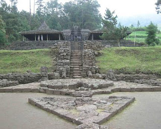
The location of the Temple Cetho Cetho temple is situated at an altitude of 1470 m above sea level. This temple was built on sloping land next to the slope of 150 o .. Cetho temple is oriented towards the east building. Cetho temple-shaped building terraces, totaling thirteen terrace and patio-terrace arrangement of an array of our porch. Until now, the temple complex is used by locals as a Hindu shrine and popular as a hermitage for the original religion of Java or Javanese (Saringedyati, 2008: 20). Location is the location of the temple is at the foot Cetho Lawu. the administrative area is located on the border between Karanganyar district which is the province of Central Java with Magetan, East Java Province. While the summit itself Lawu measured from Greenwich is located on 111 090 and 70 390.2. Lawu peak can be climbed via passage through, among others who entered the temple Cetho kecamtan Jenawi located on the western path, or road through the district Cemoro sewu Tawangmangu on the south track. Another trajectory through the District Ngrambi Ngawi, and Sarangan Magetan. Cetho temple is located at almost the top of the mountain Lawu. Lawu today is one of the famous mountain as a place that is used for meditation for most of the cult followers. Cetho temple is located enshrinement area located at higher elevations. The surrounding of the temple there are pohoh Cetho fir trees and tea plants owned by local people. Access to the temple Cetho was a little hard, sharp twisty winding roads. Background On Candi Bangunya Cetho Background on the rise and the core of this temple is a place for religious rituals, especially followers of Hindu religion. Temple Cetho (Javanese spelling: cethå) is a Hindu temple-style relics of the end of the 15th century Majapahit. Ceto temple built by King UB in 1451. The first scientific report of him was made by Van de Vlies in 1842. A.J. Bernet Kempers also do some research about it. Excavation for the purpose of reconstruction was first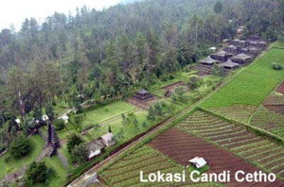 performed in 1928 by the
Archaeological Department of the Dutch East Indies. Under the circumstances when the ruins began to study, this temple has not aged that much with Sukuh. Location
of the temple is located in the hamlet of Ceto, Gumeng Village,
District Jenawi, Karanganyar district, at an altitude of 1400m above sea
level (http://id.wikipedia.org/wiki/Candi_Ceto).
The background is another reason why the temple was built above the height Cetho namely the mountain Lawu. The
concept of god because they Mountains (Parwatarajadewa) Sources of
Hindu India illustrates that the universe consists of a circular
continent, called Jambudwipa, which is home to humans and many other
animals. Jambudwipa is surrounded by seven oceans and seven series of mountains interspersed intermittently.
Circle of the universe is centered on Mount Mahameru (Meru), the cosmic mountain diedari by the sun, moon, and stars. At the peak of Mount Mahameru lies the abode of the gods. While in the eighth Mount Mahameru guarded by the gods Asta-dikpalaka. According to Buddhism was a picture of the universe almost identical to the description of the cosmos in Hinduism. Mount Mahameru the center of the universe. The
difference is outside the chain of mountains and the ocean there are
seven in all four directions of the winds there are four continents. Located on the southern continent is Jambudwipa, human habitation and various other animals. While the three other continents live in a variety of magical creatures. The universe is also surrounded by a horizon line. Located
on the slopes of Mount Mahameru lowest heaven, the fourth king of the
residence as a guardian of the world (Geldern 1982: 4-5).
At
the time of ancient Java, there is a picture of the universe in a
literary work and Brahmandapurana Bhismaparwa (10th century AD). Basically the picture of the cosmos in the literature is not much different from the source of Hindu India. World in the literature are described based on the Jambu-Dwipa. Jambudwipa Lawanasagara and surrounded by towering in the middle
Mount Mahameru as the central point of the universe. In
the north-south axis there are six other large mountain, which is
Nilawarsa, Swetagiri, and Srngawan the north; and Nisadha, Hemakuta, and
Hima in the south. In between there are seven mountain areas of residence. East-west
axis of a row after the mountain there Gandhamadana, Ketuman, and Tasik
Kulwan the west; and mountain Malyawan, Bhadraswa, then Purwasagara
(Gonda 1932: 129-39; 1936: 1)
Candi Ceto is divided into several courts. From court to court the next one to be separated by several steps. The higher the court the more sacred place. In the first courtyard, some people perform religious ceremonies. On the third terrace there is a stone structure that forms a giant turtle that is said as a symbol of Majapahit. In
front of the head of a turtle are symbols phallus (male genitalia)
along the 2 meter equipped with a decorative piercing (piercing) of type
ampallang. Turtles are the symbol of the creation of the universe while the penis is a symbol of human creation. darii suryasengkala Saka dates to 1373, or 1451 BC (photo 2),
(Http://napak-tilas-sejarah-di-candi-cetho.html).
Environmental harmony Cetho What Have The Temple Religious Diversity
performed in 1928 by the
Archaeological Department of the Dutch East Indies. Under the circumstances when the ruins began to study, this temple has not aged that much with Sukuh. Location
of the temple is located in the hamlet of Ceto, Gumeng Village,
District Jenawi, Karanganyar district, at an altitude of 1400m above sea
level (http://id.wikipedia.org/wiki/Candi_Ceto).
The background is another reason why the temple was built above the height Cetho namely the mountain Lawu. The
concept of god because they Mountains (Parwatarajadewa) Sources of
Hindu India illustrates that the universe consists of a circular
continent, called Jambudwipa, which is home to humans and many other
animals. Jambudwipa is surrounded by seven oceans and seven series of mountains interspersed intermittently.
Circle of the universe is centered on Mount Mahameru (Meru), the cosmic mountain diedari by the sun, moon, and stars. At the peak of Mount Mahameru lies the abode of the gods. While in the eighth Mount Mahameru guarded by the gods Asta-dikpalaka. According to Buddhism was a picture of the universe almost identical to the description of the cosmos in Hinduism. Mount Mahameru the center of the universe. The
difference is outside the chain of mountains and the ocean there are
seven in all four directions of the winds there are four continents. Located on the southern continent is Jambudwipa, human habitation and various other animals. While the three other continents live in a variety of magical creatures. The universe is also surrounded by a horizon line. Located
on the slopes of Mount Mahameru lowest heaven, the fourth king of the
residence as a guardian of the world (Geldern 1982: 4-5).
At
the time of ancient Java, there is a picture of the universe in a
literary work and Brahmandapurana Bhismaparwa (10th century AD). Basically the picture of the cosmos in the literature is not much different from the source of Hindu India. World in the literature are described based on the Jambu-Dwipa. Jambudwipa Lawanasagara and surrounded by towering in the middle
Mount Mahameru as the central point of the universe. In
the north-south axis there are six other large mountain, which is
Nilawarsa, Swetagiri, and Srngawan the north; and Nisadha, Hemakuta, and
Hima in the south. In between there are seven mountain areas of residence. East-west
axis of a row after the mountain there Gandhamadana, Ketuman, and Tasik
Kulwan the west; and mountain Malyawan, Bhadraswa, then Purwasagara
(Gonda 1932: 129-39; 1936: 1)
Candi Ceto is divided into several courts. From court to court the next one to be separated by several steps. The higher the court the more sacred place. In the first courtyard, some people perform religious ceremonies. On the third terrace there is a stone structure that forms a giant turtle that is said as a symbol of Majapahit. In
front of the head of a turtle are symbols phallus (male genitalia)
along the 2 meter equipped with a decorative piercing (piercing) of type
ampallang. Turtles are the symbol of the creation of the universe while the penis is a symbol of human creation. darii suryasengkala Saka dates to 1373, or 1451 BC (photo 2),
(Http://napak-tilas-sejarah-di-candi-cetho.html).
Environmental harmony Cetho What Have The Temple Religious Diversity
Candi Ceto is a relic of Hindu civilization to the 14th century Majapahit empire end. This temple has the same function as the other temples as places of worship and meditation. If Entering the second ladder after the gate, encountered a statue of Ki Ageng Krincingwesi (an ancestor figure Ceto), which remains a place of meditation for people who were Hindus Karanganyar to this day. Cetho temple is located around housing residents was predominantly Hindu religion and local beliefs such as Javanese. But at the bottom of the temple Cetho predominantly Muslim. But living in harmony despite their different beliefs. They can coexist with each other even melengkapai one another. Looks like a sense of empathy in the community there has been firmly entrenched. Not emerge until the views of fascism which is completely can lead to conflict among religious. Integration can be seen from the award and an empathy for the statues - statues that surround the temple. You see statues - statues in this Cetho enshrinement for the people who lay very fulgar. The majority of the existing statue is the embodiment of the linga yoni. Lots of replica or statues shaped vagina pallus and everywhere.
If only the people inside are not embedded mukin empathy and fandalisme destruction will occur, because the assumption that these statues he considered vulgar. But in fact behind the making of these statues have meanings that are stored. As a symbol of the vagina pallus and symbolizes fertility and strength.
 Preliminary
The temple is a place of worship of Hindus. Hindu religion is one religion in Indonesia. Indonesia is a plural society the state so natural that many religions that can be encountered here. The
arrival of Hindu religion to the archipelago and gave India its
influence when it comes to the archipelago nation and spread its
influence into the aquatic area around the 4th century.
This allegation was strengthened by the temukannya 7 yupa fruit in the form of inscriptions. The inscription reads letters Pallawa and Sanskrit language (Soekmono; 1973: 35). 7 pieces of this inscription is the monument that is used for sacrificial ceremonies. Of ceremonies that can be undertaken at the conclusion that in the Kutai pull any real hindu influence.
Then the influence of Hindu religion spread throughout the archipelago, and that gets the most influence is the area of Java. Relics
of ancient historic sites, especially in the kingdoms of the Hindu
character of many scattered throughout the archipelago. But in Java Tenggah is where we meet most temples are Hindu or Buddhist-style.
Temples
Buddhist heritage hindu kingdom is still awake and still preserved as a
tourist tujan and also as a religious ritual for Hindu and Buddhist
faiths. In
its development the temples this one started buying into the damaged
and some are affected by natural disasters like earthquake in Yogyakarta
to knock down the order of the temples there.
Preliminary
The temple is a place of worship of Hindus. Hindu religion is one religion in Indonesia. Indonesia is a plural society the state so natural that many religions that can be encountered here. The
arrival of Hindu religion to the archipelago and gave India its
influence when it comes to the archipelago nation and spread its
influence into the aquatic area around the 4th century.
This allegation was strengthened by the temukannya 7 yupa fruit in the form of inscriptions. The inscription reads letters Pallawa and Sanskrit language (Soekmono; 1973: 35). 7 pieces of this inscription is the monument that is used for sacrificial ceremonies. Of ceremonies that can be undertaken at the conclusion that in the Kutai pull any real hindu influence.
Then the influence of Hindu religion spread throughout the archipelago, and that gets the most influence is the area of Java. Relics
of ancient historic sites, especially in the kingdoms of the Hindu
character of many scattered throughout the archipelago. But in Java Tenggah is where we meet most temples are Hindu or Buddhist-style.
Temples
Buddhist heritage hindu kingdom is still awake and still preserved as a
tourist tujan and also as a religious ritual for Hindu and Buddhist
faiths. In
its development the temples this one started buying into the damaged
and some are affected by natural disasters like earthquake in Yogyakarta
to knock down the order of the temples there.
The location of the Temple Cetho Cetho temple is situated at an altitude of 1470 m above sea level. This temple was built on sloping land next to the slope of 150 o .. Cetho temple is oriented towards the east building. Cetho temple-shaped building terraces, totaling thirteen terrace and patio-terrace arrangement of an array of our porch. Until now, the temple complex is used by locals as a Hindu shrine and popular as a hermitage for the original religion of Java or Javanese (Saringedyati, 2008: 20). Location is the location of the temple is at the foot Cetho Lawu. the administrative area is located on the border between Karanganyar district which is the province of Central Java with Magetan, East Java Province. While the summit itself Lawu measured from Greenwich is located on 111 090 and 70 390.2. Lawu peak can be climbed via passage through, among others who entered the temple Cetho kecamtan Jenawi located on the western path, or road through the district Cemoro sewu Tawangmangu on the south track. Another trajectory through the District Ngrambi Ngawi, and Sarangan Magetan. Cetho temple is located at almost the top of the mountain Lawu. Lawu today is one of the famous mountain as a place that is used for meditation for most of the cult followers. Cetho temple is located enshrinement area located at higher elevations. The surrounding of the temple there are pohoh Cetho fir trees and tea plants owned by local people. Access to the temple Cetho was a little hard, sharp twisty winding roads. Background On Candi Bangunya Cetho Background on the rise and the core of this temple is a place for religious rituals, especially followers of Hindu religion. Temple Cetho (Javanese spelling: cethå) is a Hindu temple-style relics of the end of the 15th century Majapahit. Ceto temple built by King UB in 1451. The first scientific report of him was made by Van de Vlies in 1842. A.J. Bernet Kempers also do some research about it. Excavation for the purpose of reconstruction was first
 performed in 1928 by the
Archaeological Department of the Dutch East Indies. Under the circumstances when the ruins began to study, this temple has not aged that much with Sukuh. Location
of the temple is located in the hamlet of Ceto, Gumeng Village,
District Jenawi, Karanganyar district, at an altitude of 1400m above sea
level (http://id.wikipedia.org/wiki/Candi_Ceto).
The background is another reason why the temple was built above the height Cetho namely the mountain Lawu. The
concept of god because they Mountains (Parwatarajadewa) Sources of
Hindu India illustrates that the universe consists of a circular
continent, called Jambudwipa, which is home to humans and many other
animals. Jambudwipa is surrounded by seven oceans and seven series of mountains interspersed intermittently.
Circle of the universe is centered on Mount Mahameru (Meru), the cosmic mountain diedari by the sun, moon, and stars. At the peak of Mount Mahameru lies the abode of the gods. While in the eighth Mount Mahameru guarded by the gods Asta-dikpalaka. According to Buddhism was a picture of the universe almost identical to the description of the cosmos in Hinduism. Mount Mahameru the center of the universe. The
difference is outside the chain of mountains and the ocean there are
seven in all four directions of the winds there are four continents. Located on the southern continent is Jambudwipa, human habitation and various other animals. While the three other continents live in a variety of magical creatures. The universe is also surrounded by a horizon line. Located
on the slopes of Mount Mahameru lowest heaven, the fourth king of the
residence as a guardian of the world (Geldern 1982: 4-5).
At
the time of ancient Java, there is a picture of the universe in a
literary work and Brahmandapurana Bhismaparwa (10th century AD). Basically the picture of the cosmos in the literature is not much different from the source of Hindu India. World in the literature are described based on the Jambu-Dwipa. Jambudwipa Lawanasagara and surrounded by towering in the middle
Mount Mahameru as the central point of the universe. In
the north-south axis there are six other large mountain, which is
Nilawarsa, Swetagiri, and Srngawan the north; and Nisadha, Hemakuta, and
Hima in the south. In between there are seven mountain areas of residence. East-west
axis of a row after the mountain there Gandhamadana, Ketuman, and Tasik
Kulwan the west; and mountain Malyawan, Bhadraswa, then Purwasagara
(Gonda 1932: 129-39; 1936: 1)
Candi Ceto is divided into several courts. From court to court the next one to be separated by several steps. The higher the court the more sacred place. In the first courtyard, some people perform religious ceremonies. On the third terrace there is a stone structure that forms a giant turtle that is said as a symbol of Majapahit. In
front of the head of a turtle are symbols phallus (male genitalia)
along the 2 meter equipped with a decorative piercing (piercing) of type
ampallang. Turtles are the symbol of the creation of the universe while the penis is a symbol of human creation. darii suryasengkala Saka dates to 1373, or 1451 BC (photo 2),
(Http://napak-tilas-sejarah-di-candi-cetho.html).
Environmental harmony Cetho What Have The Temple Religious Diversity
performed in 1928 by the
Archaeological Department of the Dutch East Indies. Under the circumstances when the ruins began to study, this temple has not aged that much with Sukuh. Location
of the temple is located in the hamlet of Ceto, Gumeng Village,
District Jenawi, Karanganyar district, at an altitude of 1400m above sea
level (http://id.wikipedia.org/wiki/Candi_Ceto).
The background is another reason why the temple was built above the height Cetho namely the mountain Lawu. The
concept of god because they Mountains (Parwatarajadewa) Sources of
Hindu India illustrates that the universe consists of a circular
continent, called Jambudwipa, which is home to humans and many other
animals. Jambudwipa is surrounded by seven oceans and seven series of mountains interspersed intermittently.
Circle of the universe is centered on Mount Mahameru (Meru), the cosmic mountain diedari by the sun, moon, and stars. At the peak of Mount Mahameru lies the abode of the gods. While in the eighth Mount Mahameru guarded by the gods Asta-dikpalaka. According to Buddhism was a picture of the universe almost identical to the description of the cosmos in Hinduism. Mount Mahameru the center of the universe. The
difference is outside the chain of mountains and the ocean there are
seven in all four directions of the winds there are four continents. Located on the southern continent is Jambudwipa, human habitation and various other animals. While the three other continents live in a variety of magical creatures. The universe is also surrounded by a horizon line. Located
on the slopes of Mount Mahameru lowest heaven, the fourth king of the
residence as a guardian of the world (Geldern 1982: 4-5).
At
the time of ancient Java, there is a picture of the universe in a
literary work and Brahmandapurana Bhismaparwa (10th century AD). Basically the picture of the cosmos in the literature is not much different from the source of Hindu India. World in the literature are described based on the Jambu-Dwipa. Jambudwipa Lawanasagara and surrounded by towering in the middle
Mount Mahameru as the central point of the universe. In
the north-south axis there are six other large mountain, which is
Nilawarsa, Swetagiri, and Srngawan the north; and Nisadha, Hemakuta, and
Hima in the south. In between there are seven mountain areas of residence. East-west
axis of a row after the mountain there Gandhamadana, Ketuman, and Tasik
Kulwan the west; and mountain Malyawan, Bhadraswa, then Purwasagara
(Gonda 1932: 129-39; 1936: 1)
Candi Ceto is divided into several courts. From court to court the next one to be separated by several steps. The higher the court the more sacred place. In the first courtyard, some people perform religious ceremonies. On the third terrace there is a stone structure that forms a giant turtle that is said as a symbol of Majapahit. In
front of the head of a turtle are symbols phallus (male genitalia)
along the 2 meter equipped with a decorative piercing (piercing) of type
ampallang. Turtles are the symbol of the creation of the universe while the penis is a symbol of human creation. darii suryasengkala Saka dates to 1373, or 1451 BC (photo 2),
(Http://napak-tilas-sejarah-di-candi-cetho.html).
Environmental harmony Cetho What Have The Temple Religious Diversity
Candi Ceto is a relic of Hindu civilization to the 14th century Majapahit empire end. This temple has the same function as the other temples as places of worship and meditation. If Entering the second ladder after the gate, encountered a statue of Ki Ageng Krincingwesi (an ancestor figure Ceto), which remains a place of meditation for people who were Hindus Karanganyar to this day. Cetho temple is located around housing residents was predominantly Hindu religion and local beliefs such as Javanese. But at the bottom of the temple Cetho predominantly Muslim. But living in harmony despite their different beliefs. They can coexist with each other even melengkapai one another. Looks like a sense of empathy in the community there has been firmly entrenched. Not emerge until the views of fascism which is completely can lead to conflict among religious. Integration can be seen from the award and an empathy for the statues - statues that surround the temple. You see statues - statues in this Cetho enshrinement for the people who lay very fulgar. The majority of the existing statue is the embodiment of the linga yoni. Lots of replica or statues shaped vagina pallus and everywhere.
If only the people inside are not embedded mukin empathy and fandalisme destruction will occur, because the assumption that these statues he considered vulgar. But in fact behind the making of these statues have meanings that are stored. As a symbol of the vagina pallus and symbolizes fertility and strength.


